The Manitoba Wildfire Service advises the eastern and northern parts of the province have a high to very high fire danger level, with some areas of extreme fire danger level. The western and central regions of the province are at a low to moderate fire danger level.
Manitoba Parks advises Bakers Narrows Provincial Park will reopen for seasonal campers on Friday, July 25. Nightly campsites will reopen on Friday, Aug. 1. Wekusko Falls Provincial Park closure has been extended to Aug. 7. For updates on park closures, visit www.manitobaparks.com.
Manitoba Wildfire Service has cancelled all burn permits for the Burn Permit Area, with no new burn permits issued at this time. Additionally, travel permits are required within active fire boundaries. To view active fire boundary maps, visit www.gov.mb.ca/conservation_fire/Fire-Maps/fireview/fireview_map.html. To apply for a travel permit, contact a Natural Resources and Indigenous Futures district office and visit www.gov.mb.ca/nrnd/co/index.html to find a location.
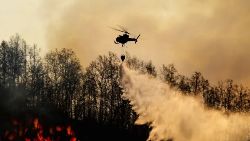
Manitoba continues under a provincial state of emergency, under the Emergency Measures Act due to a wildfire season that is now the worst on record in the last 30 years, with more than one million hectares (ha) of area burned in the province. The state of emergency is in effect until Aug. 8 and if necessary, may be extended.
Fires of note
The Manitoba Wildfire Service continues to respond to 120 active wildfires across the province, a total of 331 wildfires to date, well above the average for this date of 243 total fires.
Fires of note include:
East region:
- Fire EA061 remains out of control at approximately 293,825 ha. A closure and mandatory evacuation order continues for parts of Nopiming Provincial Park and the entire areas of Wallace Lake and South Atitaki provincial parks. PR 314 remains closed through Nopiming Provincial Park, as well as PR 304 east of Bissett. The southern portion of Atikaki Provincial Park is also closed including the Bloodvein and Gammon river corridors and Aikens Lake.
West region:
- Fire WE017, located near Sherridon and the city of Flin Flon, is approximately 347,100 ha and is out of control. For the safety of personnel, boaters are asked to avoid waterways being utilized by Manitoba Wildfire Service tankers and aircraft.
- Fire WE025, located near Mathias Colomb Cree Nation (Pukatawagan), is approximately 62,075 ha and is being monitored. The fire is contained around Mathias Colomb Cree Nation (Pukatawagan) but a mandatory evacuation order continues.
- Fire WE028, located 10 kilometres (km) from Bakers Narrows Provincial Park, is approximately 7,190 ha and is out of control.
- Fire WE052, located 16 km from Snow Lake, is approximately 21,480 ha and is out of control. A mandatory evacuation order is in place for the town of Snow Lake. Wekusko Falls Provincial Park closure will remain in place until August and a mandatory evacuation order continues for park users.
- Fire WE053, located 13 km from Snow Lake, is approximately 8,745 ha and is out of control.
North region:
- Fire NO002, located near the town of Lynn Lake, is approximately 84,270 ha and is out of control.
- Fire NO042, located 12 km southwest from the town of Lynn Lake, is approximately 14,450 ha and is out of control. A mandatory evacuation order is in place for the town of Lynn Lake and Marcel Columb First Nation.
- Fire NO005, located near Pimicikamak Cree Nation (Cross Lake), the Incorporated Community of Cross Lake, Jenpeg Generating Station and Whiskey Jack Landing, is approximately 149,560 ha and is out of control.
- Fire NO010, located near Tataskweyak Cree Nation (Split Lake), is approximately 25,225 ha and is out of control. A mandatory evacuation order remains in place for Tataskweyak Cree Nation (Split Lake).
- Fire NO026, located four km from the town of Leaf Rapids, is approximately 9,160 ha and is out of control. A mandatory evacuation order is in place for the town of Leaf Rapids.
- Fire NO047, located 25 km from the town of Leaf Rapids, is approximately 15,525 ha and is out of control. A mandatory evacuation remains in place for the town of Leaf Rapids.
- Fire NO061, located 14 km from the city of Thompson, is approximately 16,370 ha and is out of control.
- Fire NO079 located near Kistiganwacheeng (Garden Hill Anisininew Nation), is approximately 2,865 ha and is out of control. A mandatory evacuation remains in place for Kistiganwacheeng (Garden Hill Anisininew Nation) and Island Lake (Stevenson Island) continues evacuations.
- Fire NO113 located nine km from Leaf Rapids, is approximately 490 ha and is out of control.
- Fire NO129, located four km from Kischewaskahegan (York Factory First Nation), is approximately 45 ha and is being held.
Information and resources for evacuees
The primary evacuation reception centre in Winnipeg is now located on the second level of the RBC Convention Centre at 375 York Ave. Evacuees can attend this location to register with the Canadian Red Cross, and to access supports and services. Evacuees can also call 1 (800) 863-6582.
In response to the need for shelter for wildfire evacuees, Emergency Social Services continues to work with the Canadian Red Cross to operate congregate shelters in Winnipeg including at the RBC Convention Centre at 375 York Ave, Leila Soccer Complex at 770 Leila Ave and the University of Winnipeg Axworthy Health and RecPlex at 350 Spence St.
For the safety of both evacuees and frontline and firefighting personnel, the province is reminding Manitobans not to enter areas under a mandatory evacuation until local authorities identify the situation is safe and evacuees are able to return.
The Manitoba Emergency Management Organization recommends evacuees leaving their communities due to wildfire bring their medications, identification, phone chargers, important documents, any needed baby supplies and a change of clothing.